
On a mountain holiday, thanks to my daughters, I discovered Geocaching..
What is it?
Geocaching is a kind of outdoor treasure hunt based on GPS involving a worldwide community of more than 10 million people.
How does it work?
On one side are the Hiders who hide containers (called caches) around the world, mapping them in an application by entering their GPS coordinates.
There are more than 3 million active caches worldwide.
On the other side (the majority) are the Seekers who search for caches using their smartphone’s GPS and the latitude and longitude coordinates supplied by Hiders.
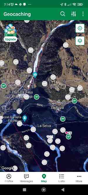
Seekers are often also helped by useful hints and photographs of the area where the container is hidden.
Sometimes the clues are very original and include little riddles. For example, one location said: ‘Come in… and remember a famous Pink Floyd song.’ My daughters had no idea what it meant (for obvious age-related reasons), so I suggested they look at the large wall in front of them 😉.
The most widely used geocaching platform today is undoubtedly the website and community geocaching.com and involves using the associated app.
Once you find a cache, open it and take out the logbook (a small paper register), where you record your visit with the date and the name/alias you use on Geocaching.
It is also good practice to record the visit in the app (clicking LOG), selecting ‘Found it’ or ‘DNF’ (if it is no longer there, allowing the hider to restore the cache), and adding a comment and/or photograph.
My family and I searched for containers in the mountains of Trentino, and it was great fun: the children kept walking and searching until sunset.
The following images show some examples of caches.
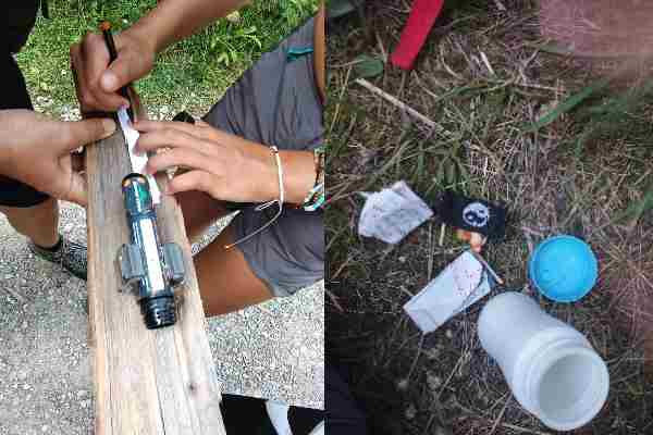
There are different types of cache; the app indicates whether they are large or small and their type. For example, the container in the next photograph is magnetic, and we found it attached to a pole at the cable-car entrance.
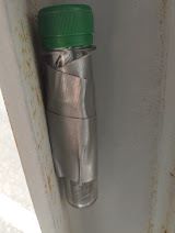
An important characteristic of caches is that they are not clearly visible, for two main reasons:
- to make the discovery game more fun
- to prevent curious people unaware of the project from taking the containers away
When Geocaching began
We have seen that GPS underpins how Geocaching works.
GPS originated in the 1960s for military purposes, when the US Department of Defense began exploring the possibility of using satellites for military navigation and positioning.
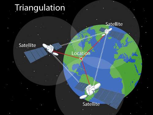
Civilian use was not allowed — or, more precisely, the signal was deliberately degraded to make the coordinates inaccurate (selective degradation).
This continued until 2 May 2000 when, under the Clinton administration, the US decided to make ‘precise’ GPS available for non-military use too. This day is called Blue Switch Day (the name comes from the practice of using blue to indicate military operations or restricted systems).
For GPS enthusiasts, switch day was memorable, and the community immediately began asking how the technology could be used.
The first person to think of the object-hiding game was Dave Ulmer, an IT consultant, who immediately placed a black bucket in the Oregon woods near Beavercreek on 3 May.
The bucket also contained a guestbook, a pencil and various prize objects (a slingshot, books and videos).
Ulmer’s next step was to share the following coordinates with the online sci.geo.satellite-nav group:
N 45° 17.460 W 122° 24.800
The black bucket was effectively the first cache placed, although in the early years the activity was limited to a very technical community (you had to own a GPS device).
The spread and integration of GPS into all smartphones was the real enabler of the Geocaching ecosystem, which has grown enormously in recent years.
What is the aim? What benefits does the activity offer?
A friend once asked me: what is the point of searching?
In my view, the beauty of Geocaching lies in the following:
- the sense of adventure and the search, taking you back to being a child reading about hidden treasures
- the exploration: geocaching usually takes place in beautiful natural or artistic locations, allowing you to discover and learn about an area (clicking a cache’s description in the app provides information about its location).
- you feel part of a large community spread around the world, and it is lovely to see people from other countries having followed the same routes as you. If you love the environment, the community’s values are also strongly oriented towards respecting it.
- it is good for your health because it encourages you to move and walk
- it is fun: it is a game, and it is lovely to do with children, family and friends
- the children go back to playing outdoors and, in this case, the smartphone does not glue them to an armchair but encourages them to move (after a day of hiking, my daughters kept walking until sunset, driven by the desire to find another container).
Tourism marketing and Geocaching
From a marketing perspective, Geocaching is a perfect Phygital service: physical + digital.
In tourism marketing Geocaching can be a fantastic tool for promoting an area in an innovative, enjoyable way.
Geocaches should be positioned to introduce people to the area’s most beautiful places, whether natural, artistic or historical.
It is important to enrich the cache with information (readable in the app), so people can learn in depth about the different locations where they are hidden.
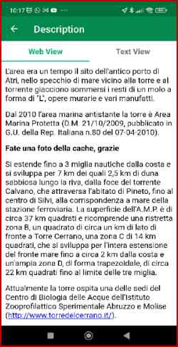
Below is an example of a container’s description explaining the origins and value of the area where it was found (in this case, the beautiful Torre del Cerrano in Pineto’s marine protected area).
Geocaching.com offers the opportunity to create GeoTours: with this format, we can place several linked caches along the route we want to promote (technically called multicaches: once the first is found, it contains directions to find the others).
At the end of the route, it makes sense to include a prize, such as a free park or museum ticket.
Bear in mind, though, that creating a GeoTour project costs money. In return, it receives worldwide visibility and promotion through publication on geocaching.com, social sharing and the newsletter (the reach of these tools should be carefully assessed).
A GeoTour makes sense when organised by the local tourism promotion body, municipality or trade associations.
Another advantage is that it can redirect tourist traffic to less-known, less-visited but beautiful areas that deserve a visit.
IMPORTANT: once a GeoTour is created, do not forget to maintain it, checking that the containers are present and intact. Otherwise, it risks backfiring and creating a negative experience.
Even without GeoTours, though, having caches in an area is valuable.
To engage tourists and build loyalty, organising events and/or continually creating new routes can also make sense (perhaps with a locally produced newsletter).
Accommodation providers (hotels, B&Bs, campsites, etc.) can introduce the project to suitable customers with a short briefing on how it works and where to start.
Personally, I hope Geocaching grows in Italy, perhaps supported by local initiatives and combined with Orienteering (a similar, somewhat more competitive activity that also has great tourism-marketing potential).
Italy has such a wealth of natural, historical and artistic treasures that we are spoiled for choice about where to place caches!